

The Aral Sea, almost gone
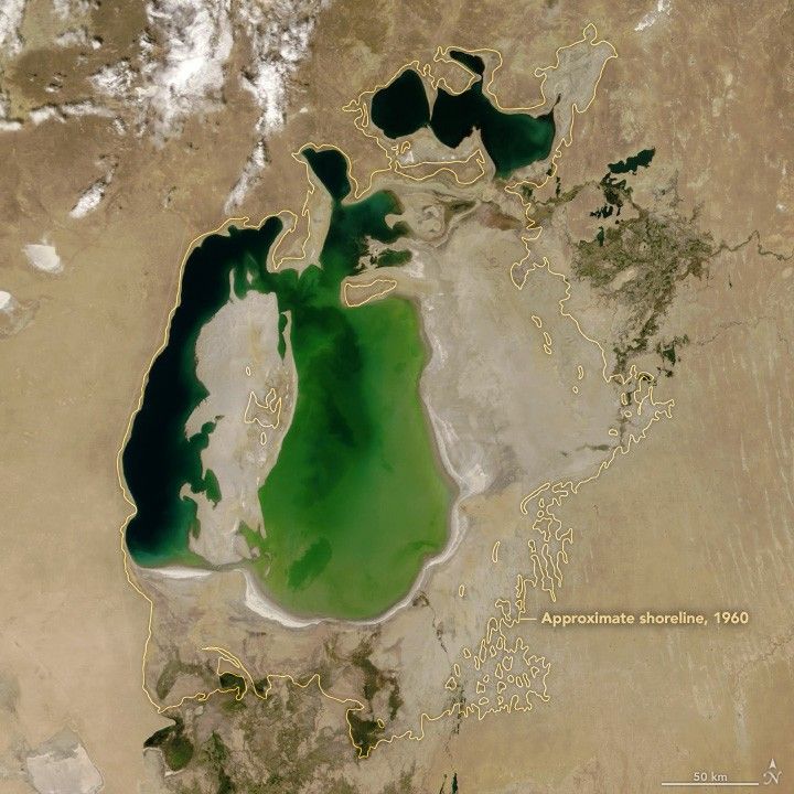
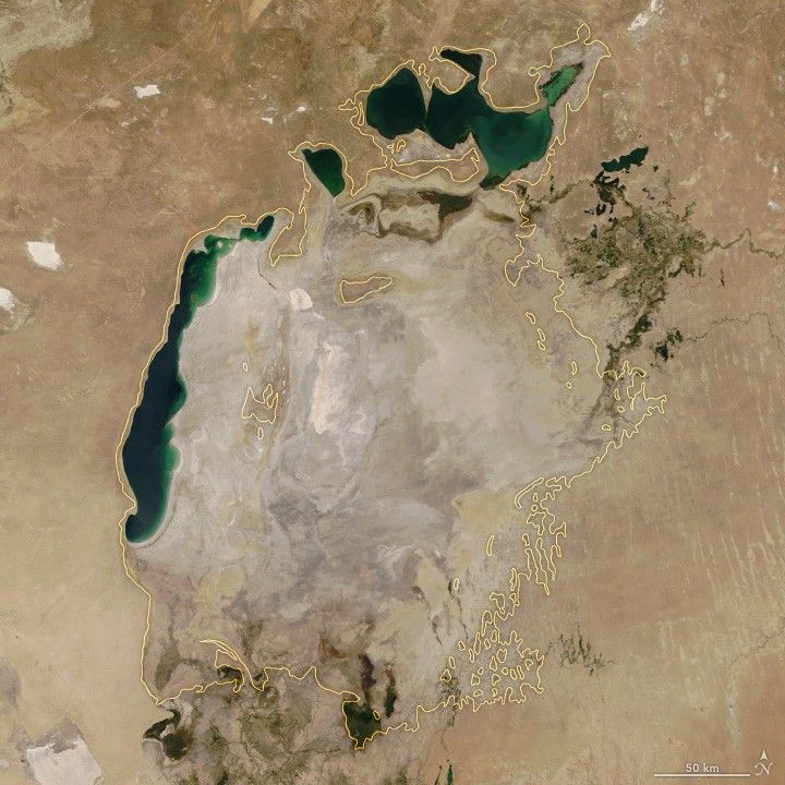
It used to be the fourth-largest lake on Earth. The Aral Sea, on the border of Kazakhstan and Uzbekistan, covered roughly 68,000 square kilometres in 1960, about the area of Ireland. Then the Soviet Union diverted the two rivers that fed it to irrigate cotton fields in Central Asia. The sea began to shrink.
Landsat photographed every stage of the collapse, year after year, from 1972 onwards. By 2014, the eastern lobe of the South Aral Sea had completely disappeared. The remaining water became more than three times saltier than the ocean, and every native fish species died. The exposed lakebed turned into a toxic plain of pesticide-laden dust.
One detail that gives the story a small note of hope: in 2005, Kazakhstan used Landsat-derived models to design and build the Kok-Aral dam, partially restoring the North Aral. Fisheries recovered there. The South Aral did not. Source: USGS EROS →
Columbia Glacier, 20 kilometres of ice lost
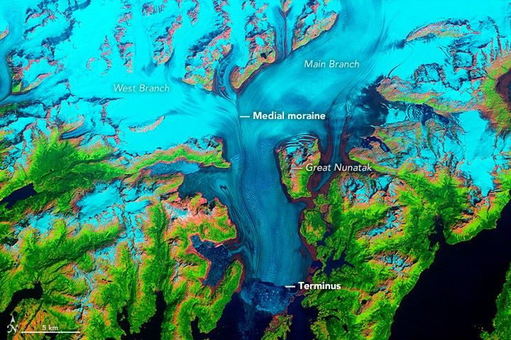
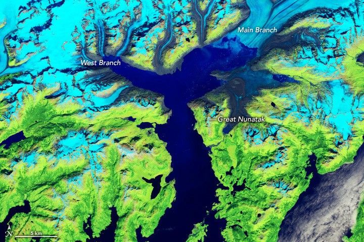
When British explorers charted Columbia Glacier in Alaska in 1794, its terminus touched Heather Island in Prince William Sound. It stayed there for 186 years. Then, in 1980, something shifted. The glacier began retreating up its fjord, and it has never stopped.
Landsat 5, 7, 8, and 9 have documented every year of the retreat in false-colour imagery. The main branch has now lost more than 20 kilometres of ice and more than half its total volume. In 2011, the terminus split into two separate glacier systems. By 2014, the main branch lost contact with the seabed and became tidally affected 12 kilometres upstream of its 1980 face. Columbia Glacier alone is responsible for nearly half of all ice loss in Alaska's Chugach Mountains.
Source: NASA Earth Observatory →
The Amazon fishbone
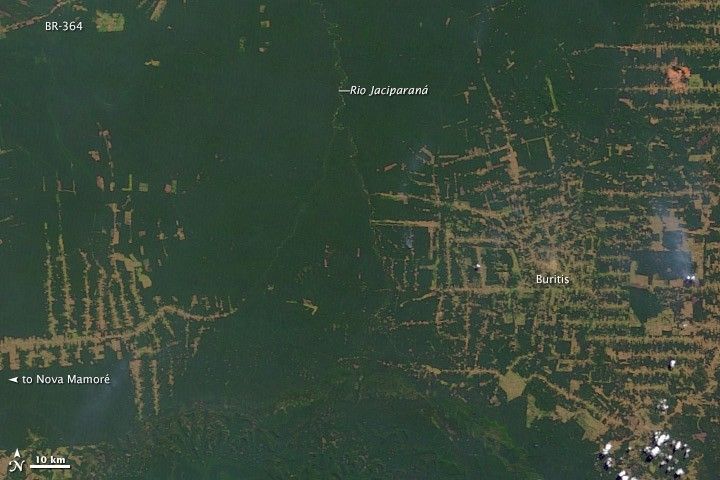
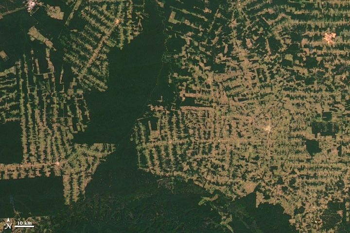
From orbit, you can see exactly how a rainforest dies. Roads appear first, then clearings branch off them in a pattern that looks like the bones of a fish. Landsat captured this in Rondonia, Brazil, where a Kansas-sized stretch of forest was reduced by a third in a single generation.
The numbers are stark: 4,200 square kilometres cleared by 1978, 30,000 by 1988, 53,300 by 1998, 67,764 by 2003. By the early 2000s, Brazil was losing more than 20,000 square kilometres a year in some seasons, an area close to the size of New Jersey. Landsat's 30-metre pixels are just fine enough to detect individual clearings and small fires, and the Brazilian government's deforestation monitoring system, PRODES, was built on Landsat 5 and 7 data. PRODES is one reason deforestation has since slowed.
Source: NASA Earth Observatory →
Mount St Helens, the largest landslide in recorded history
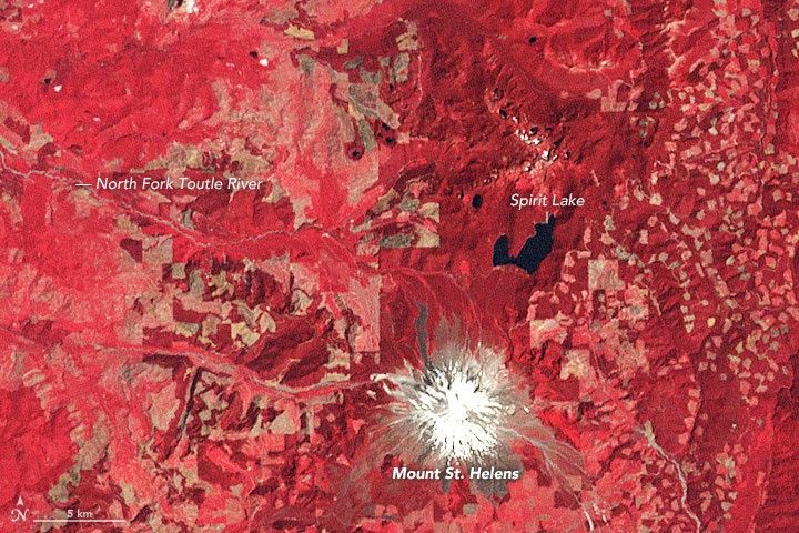

Landsat was already watching Mount St Helens when it began shaking in March 1980. On the morning of 18 May 1980, the largest landslide in recorded history reshaped the Pacific Northwest in minutes. Volcanic debris buried 14 miles of the North Fork Toutle River under an average of 150 feet of rubble, with drifts up to 600 feet deep. The blast spread across 230 square miles and felled 4 billion board-feet of timber.
Forty-six years on, Landsat is still documenting the recovery. The first plant to recolonise the blast zone was a prairie lupine that can pull nitrogen directly from the air, bootstrapping the soil chemistry for everything that followed. By the 1990s, the northwestern quadrant was visibly greening. By 2016, vegetation had returned to most of the blast zone except the bare Pumice Plain. The archive holds it all.
Source: NASA Earth Observatory →
Dubai, built from the sea
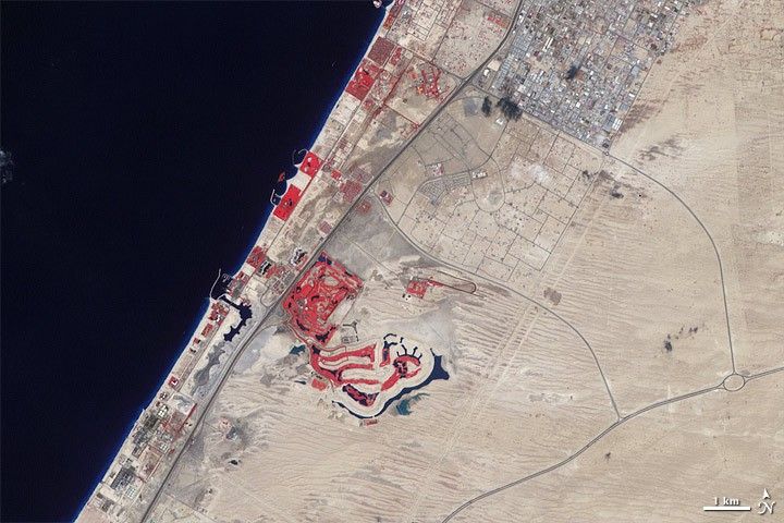
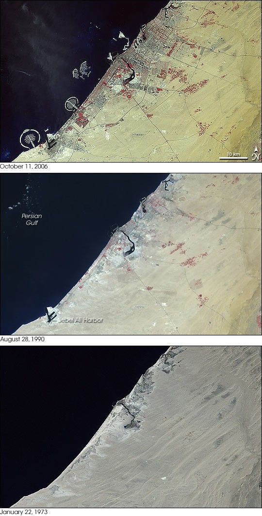
In 1972, when Landsat 1 launched, the strip of coast that would become modern Dubai was nearly empty desert. Two decades on, the city was visible from orbit. By 2006, when Landsat 7 photographed the same coastline, the Palm Jumeirah, the largest artificial island ever built, was complete, and the "World Islands" archipelago, also dredged from the sea floor, was under construction.
The Palm Jumeirah is built from sand dredged from the Arabian Gulf and protected by rock breakwaters shaped to be visible from space. The same Landsat archive that documented Dubai's growth also monitors the desertification creeping across the Gulf states.
Source: NASA Earth Observatory →
Las Vegas, desert to metropolis
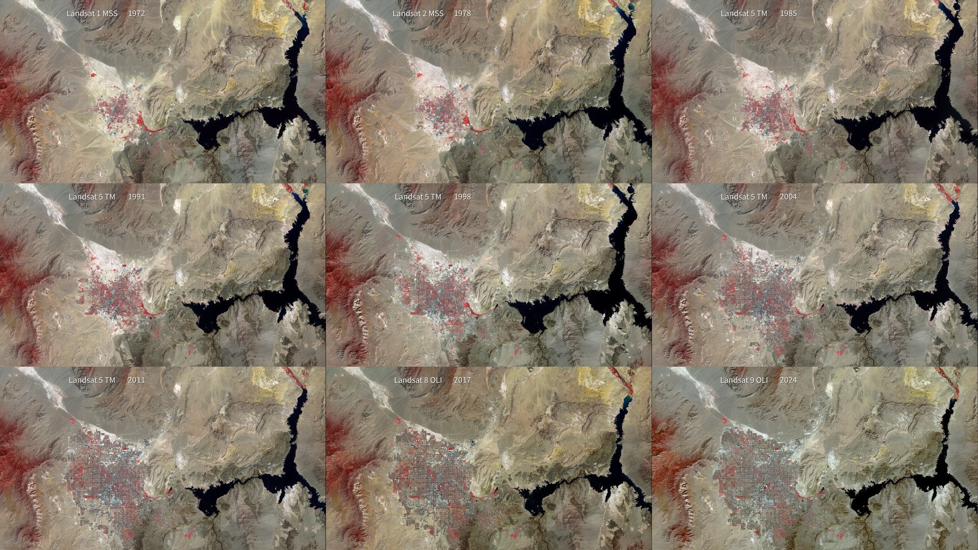
In 1972, the year Landsat 1 launched, Las Vegas had 358,000 residents. The desert around the city was mostly intact. Fifty-two years later, the metropolitan area is home to nearly 2 million people, one of the fastest-growing in the world.
Landsat sees urban Las Vegas in false colour: streets and impervious surfaces appear grey, irrigated parks and golf courses appear red, and bare desert is tan. The contrast between the 1972 frame and the 2024 frame needs no caption. The growth was driven by gambling legalisation, the Hoover Dam, and irrigation infrastructure, all of which are visible in the archive.
Source: NASA Scientific Visualization Studio →
A forest moving north
Full credits
Credit: NASA’s Goddard Space Flight Center.
Producer & Writer: Chris Burns (eMITS). Visualizer: Ross K. Walter (SSAI). Technical support: Aaron E. Lepsch (ADNET Systems, Inc.). Music: “Rise of Chance” by Lester Frances & Mike Fraumeni [ASCAP], ELIAS Music.
Source: NASA Scientific Visualization Studio →
In February 2026, a NASA Goddard study published in Biogeosciences used 224,026 Landsat scenes, spanning 1985 to 2020, to prove that the world's largest forest is shifting poleward. The boreal belt stretches across Russia, Canada and Scandinavia. Across 36 years of Landsat data, it expanded by 0.844 million square kilometres, a 12% increase, with gains concentrated between 64 and 68 degrees north.
The young new-growth forest holds an estimated 1.1 to 5.9 petagrams of carbon, a discovery with direct implications for climate projections. The boreal biome is warming faster than any other forest type on Earth, and the only reason we know the forest itself is responding in this way is that Landsat has been watching every part of the planet, continuously, since 1972.
Source: NASA Landsat Science →
Sentinel-2 watches the Great Salt Lake disappear

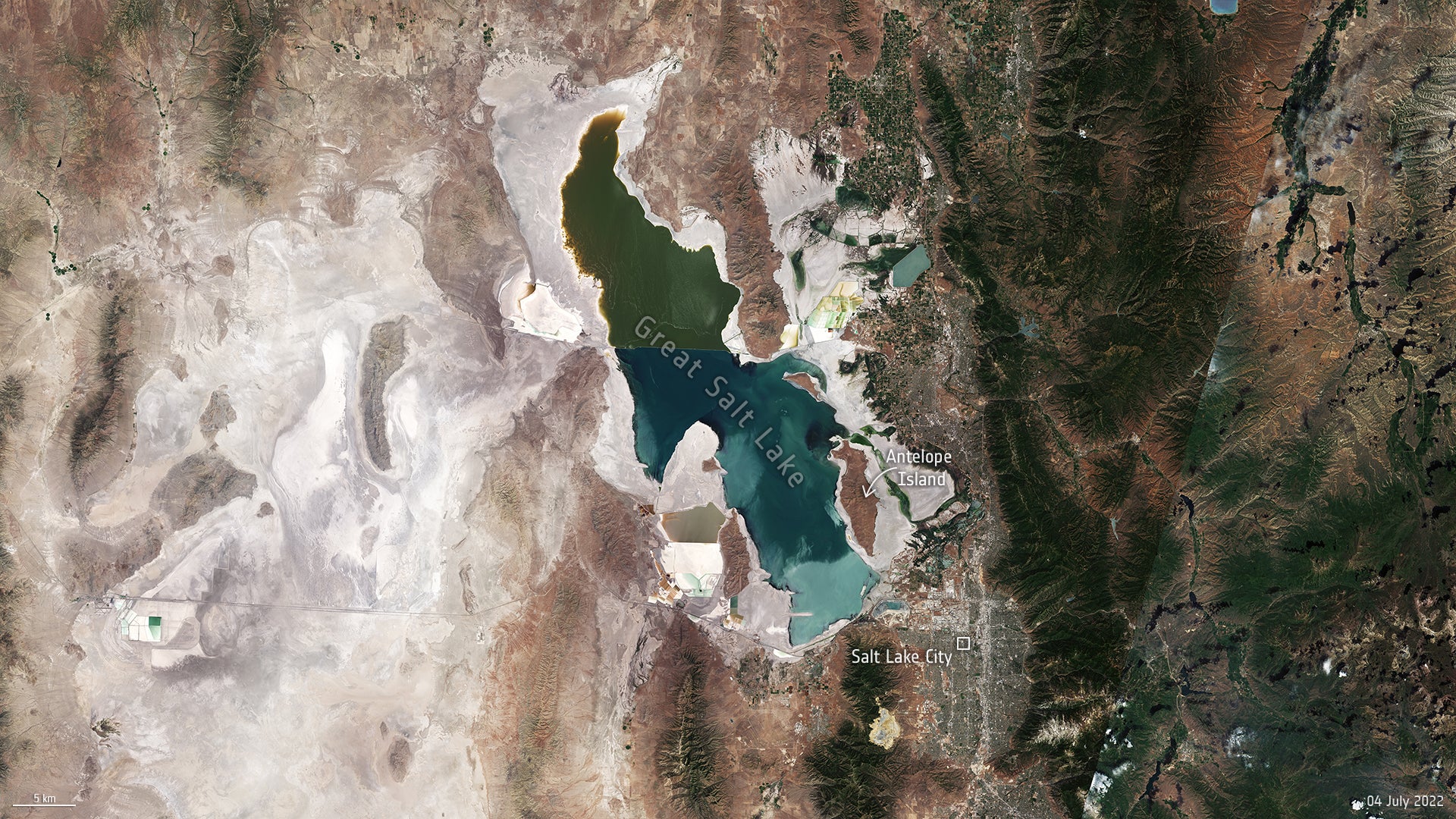
Image: contains modified Copernicus Sentinel data (2022), processed by ESA, CC BY-SA 3.0 IGO. 1985 reference frame: US Landsat 5 via USGS.
Landsat has watched Earth since 1972, but it does not watch alone. The European Space Agency's Copernicus Sentinel-2 mission launched in 2015 and now revisits every patch of land every five days at 10-metre resolution. When the two archives are placed side by side, the result is a continuous, half-century time-lapse of the planet, and it tells stories Landsat alone cannot.
Utah's Great Salt Lake is one of them. On 4 July 2022, Sentinel-2 captured the lake at the lowest surface elevation in its recorded history, 1,277 metres above sea level, the lowest since US records began in the mid-1800s. The lake now holds little more than a quarter of the water it held at its 1987 peak, and has lost nearly half of its historic surface area. Around 2,000 square kilometres of lakebed, an area the size of Tenerife, sit exposed to the wind.
The exposed lakebed is not inert. Sentinel-5P measurements of the dust plumes blowing off it show traces of copper, arsenic and other heavy metals carrying into the air over Salt Lake City. Brine shrimp populations are crashing as the remaining water grows saltier, and the birds that feed on them are following. Sentinel-2 will continue documenting the lake every five days, regardless of what happens next. Source: ESA Observing the Earth →
Imagery: NASA and the U.S. Geological Survey (Landsat programme, public domain) and the European Space Agency via the Copernicus programme (Sentinel data, Copernicus Open Licence). Skylit Studio is not affiliated with or endorsed by NASA, USGS, ESA or the European Union.

